Event security teams have spent years hardening gates, concourses, and perimeters. The cameras look good, the fencing is dialed in, and the playbook for crowd management is familiar.
What has changed is everything above that plan.
Low‑cost drones now give anyone with a few hundred dollars and a tutorial the ability to put a flying camera—or a flying payload—over a packed venue in minutes. At test sites near major stadiums, compact radar and Remote ID receivers routinely see 200+ drone tracks in a single week within a few kilometers of the venue. Real‑estate shoots, hobby flights, inspections, and unknown operators are all sharing the same airspace as your next playoff game or city festival.
Most of that activity never shows up on a ground‑only camera plan.
Why Ground‑Only Security Isn’t Enough Anymore
Most large‑event security programs were built for a two‑dimensional world. Fences, bollards, and magnetometers protect fixed perimeter lines. Cameras watch entries, concourses, and parking lots. Officers and marshals fill the gaps between hard infrastructure.
Drones change the geometry of risk.
A small quadcopter can lift off from outside your perimeter, climb above camera elevation, and hover over gates, VIP zones, or the field. The pilot may be standing blocks away on a sidewalk that has never appeared in any security plan. Even benign flights can generate calls to 911 or political scrutiny if there is no clear way to see what is happening and respond with confidence.
Two operational realities make this even harder:
- Timelines are short. FIFA matches, Super Bowls, and large civic festivals often introduce new requirements weeks, not years, before kickoff. There is no time to trench fiber, pour concrete, or erect permanent towers.
- Operations are multi‑stakeholder by default. City police, stadium operations, private security, and emergency management all share risk, but they do not always share systems or a single view of the airspace. One agency may see a track on a specialized system; another hears a report over the radio.
Telling these teams simply to “watch the sky” with existing ground cameras and patrols is a recipe for missed detections, conflicting reports, and over‑ or under‑reaction. A sustainable approach requires tools built for the 3D problem—and a way to integrate those tools into the plans you already run on game day.
The New Blind Spot in Large‑Event Security: Low‑Cost Drones
From the command center, it is easy to feel like the bases are covered. You see cameras on every gate, ground perimeters and traffic plans have been refined over multiple seasons, and mutual‑aid agreements are in place.
The picture looks very different a few hundred feet up and a kilometer or two out.
In Provo, Utah, Spotter Global set up compact surveillance radar and Remote ID sensors near a major college stadium. Over a routine week they recorded more than 200 drone tracks in the surrounding area. Some were harmless hobby flights and real‑estate shoots; others followed patterns that deserved a closer look. Operators launched from parking lots, neighborhoods, and side streets that would never be inside a traditional camera plan.
Similar patterns show up around city‑center festivals and parade routes. The air above the event is busy even when command staff believes it is quiet.
For stadium operators, city police, and municipal partners, that creates a 3D risk surface that legacy plans were never designed to manage. Open‑air bowls and rooflines become potential flight paths. Temporary stages and vendor streets sit under unseen drone traffic. Multiple agencies share responsibility but rarely share a common picture of what is overhead.
The core problem is not just what one malicious drone could do. It is that teams are often blind to the volume and behavior of everyday drone traffic near their venue until something goes wrong. Any realistic counter‑drone program has to start by closing that visibility gap.
The Counter‑Drone Technology Landscape: Strengths and Limits
Vendors often talk about “complete drone defense,” but serious programs for stadiums and large civic events draw from a familiar set of building blocks. Understanding what each layer does well—and where it falls short—makes it easier to design a practical stack instead of chasing a magic sensor.
Remote ID Sensors: The License Plate in the Sky
Remote ID is often the best starting point for drone detection at major events. Compliant drones broadcast identification and flight data; ground receivers decode those packets to show who is flying what and where.
The strengths are clear. Remote ID offers broad area coverage at relatively low cost, and properly decoded packets are effectively zero‑false‑alarm: if you see a valid Remote ID message, it is a drone. Many systems also give you both drone and pilot location, which is critical for safe interdiction.
The limits are just as important. Remote ID only sees compliant, broadcasting drones. Older airframes, modified systems, and purpose‑built “dark” drones can operate without that signal. Coverage also depends on the RF environment and line of sight; buildings and clutter can create pockets where reception is weaker.
On its own, Remote ID is not a counter‑drone program. It is a powerful first layer for understanding baseline traffic and separating authorized flights from the unknown.
RF Detection and Direction Finding: Listening for Control Links
RF systems listen for the radio protocols between drones and controllers. In the best cases they can detect non‑Remote‑ID drones and estimate or pinpoint the operator’s location.
In dense urban and stadium environments, however, RF tools must be tuned carefully. They compete with a forest of other radios, vehicles, networks, and infrastructure. Without that tuning, they can generate false positives and operator fatigue. Newer drones may also use encrypted or frequency‑hopping links that are harder to classify reliably.
RF is most effective as a complement to other layers when you understand what it adds and what noise it introduces.
Compact Radar: Seeing What Doesn’t Want to Be Seen
Radar does not care whether a drone is broadcasting. Compact surveillance radar, like the systems built by Spotter Global, is tuned to detect small, fast‑moving targets in cluttered environments and to track both air and ground movement over wide areas.
For large‑event counter‑drone programs, this matters because it brings dark drones and low‑altitude movement into view, day or night and in a wide range of weather conditions. A relatively small number of compact radars can cover large volumes of airspace.
The tradeoff is that radar sees everything that moves. Without smart classification and other layers, you can quickly end up looking at a storm of bird and clutter tracks. Radar is most powerful when it works in concert with cameras and analytics that help operators understand which tracks matter.
EO/IR Cameras and Video Analytics: Turning Tracks into Reality
Electro‑optical and infrared cameras provide the visual confirmation layer. Once Remote ID or radar identifies an area of interest, PTZ and thermal cameras show what is actually there and how it is behaving.
Video turns abstract tracks into something operators, command staff, and decision‑makers can see and trust. Recorded clips and still images become evidence for investigations and post‑event reviews. Video analytics can further help distinguish drones from birds, aircraft, or ground clutter once the field of view has been narrowed.
The constraint is coverage. Cameras have narrow fields of view, and trying to ring an entire stadium footprint with fixed EO/IR alone becomes cost‑ and infrastructure‑prohibitive very quickly.
Taken together, these technologies point to a simple conclusion that is reinforced by real deployments: no single layer is sufficient. Effective programs combine Remote ID, radar, cameras, and supporting analytics in a way that matches the venue and the mission.
What “Layered” Really Means in the Field
“Layered security” is one of the most common phrases in this space. In practice, for stadiums and civic events it has a very concrete meaning.
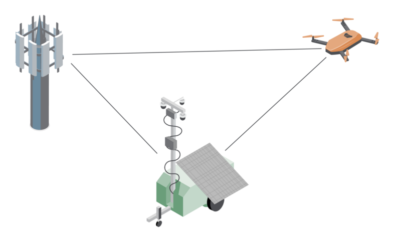
The first layer is baseline awareness. One or more Remote ID receivers—mounted on a rooftop, hill, or Mobile Pro mast—build a live picture of compliant drones and pilots in a two‑ to three‑kilometer radius. Planners see how much drone activity exists on ordinary days. Command staff can quickly separate authorized flights, such as broadcast crews, from unknown operators. Historical logs of hundreds of weekly flights become powerful tools for briefing leadership, boards, and councils.
The second layer focuses on dark drones and ground movement. Compact air‑search and ground radars mounted on mobile platforms fill in what Remote ID and fixed cameras miss. Air radar surfaces drones that are not broadcasting or that use non‑standard links. Ground radar tracks vehicles and people moving in approach routes, overflow parking, and vendor streets—especially below the horizon of existing cameras.
The third layer provides camera‑driven confirmation. PTZ and thermal cameras on Mobile Pro trailers and power‑sentry units are cued by radar and Remote ID. Instead of sweeping the sky at random, they move with purpose to verify specific tracks. Operators can distinguish nuisance hobby flights from genuine threats and capture video for evidence or training.
The final layer is the command‑center view and history. Systems like Spotter Global’s Networked IO and Integrated Management Center bring detections, video, and health telemetry into a single operational picture. Multiple agencies can work from the same screen. After the event, they can replay how many flights occurred, where they launched from, and how responses unfolded.
In one Fourth of July deployment, that layered picture allowed police to identify and intercept drone operators near a stadium by following correlated radar, Remote ID, and camera data to a specific launch point—without guesswork or conflicting reports.
When these layers are delivered on mobile platforms, security teams finally have a practical way to see, understand, and act on low‑altitude drone activity over major events.
Why Mobility and Health Monitoring Matter More Than Spec Sheets
Many write‑ups on stadium drone security stop at the sensor spec sheet. Range, beam patterns, and AI models all matter, but for public‑safety teams two questions are just as important:
- Can we deploy this in weeks, not years
- Will it stay up when 70,000 people are in the building?
Deploying on Real Timelines
Event calendars move quickly. Capital projects do not. The difference often determines whether a counter‑drone plan is implemented this season or left on the whiteboard.
Mobile Pro radar trailers and power‑sentry units are designed around the realities of event operations. Lead times are measured in two to six weeks, not multi‑year buildouts. On site, teams routinely move from “unbox” to “live” in about an hour and a half, including power‑up, connectivity checks, and basic calibration.
Because platforms bring power, connectivity, and mounting hardware with them, they can be staged in places permanent cameras rarely reach: remote and overflow parking, vendor streets, nearby parks, or hilltops overlooking a venue. The same equipment can serve a stadium one week and a city festival or critical‑infrastructure site the next.
Staying Online When It Matters
The other half of the equation is uptime. When a stadium is full, “we lost the feed” is not acceptable.
This is where health monitoring shifts from a nice‑to‑have to a core requirement. Mobile Pro’s MP Status platform tracks power, communications, and key sub‑components on each trailer and power‑sentry. Spotter Global’s Integrated Management Center monitors radar, Remote ID sensors, and video AI across multiple sites.
If a radar stops reporting, a camera loses PTZ control, or a network path drops after a storm, teams see it early enough to act before gates open. That is the difference between having technology on paper and having a trusted operational system when crowds arrive.
Partnering for Capability Instead of Doing It All Yourself
Modern counter‑drone programs are too complex for one vendor to build every piece at a best‑in‑class level. Mobile Pro Systems and Spotter Global approach the problem as technology partners, not as a single “do‑it‑all” provider.
Spotter Global pioneered compact surveillance radar and brings deep experience across defense, critical infrastructure, and event security. Mobile Pro Systems focuses on the platform side—trailers, power, connectivity, and health management that keep advanced sensors in the field and online.
By integrating Spotter Global’s radar intelligence into Mobile Pro’s mobile platforms, security teams avoid both extremes: generic sensors bolted onto a trailer with no long‑term support, or a fragile lab project that is hard to maintain. Instead, they get proven radar capabilities inside platforms purpose‑built for demanding public‑safety and stadium environments.
Designing a Practical Deployment for Your Next Major Event
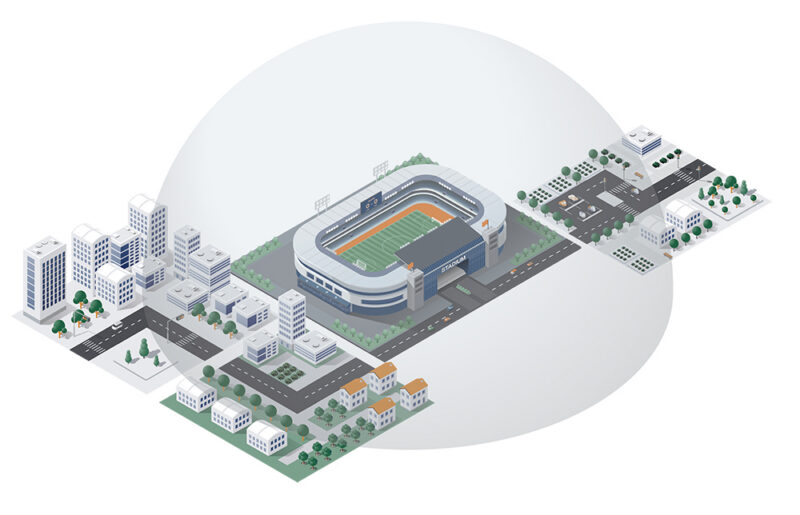
Architecture A: Single‑Venue, High‑Profile Game
For a major game at a stadium with surrounding parking and tailgating zones, a common approach begins with wide‑area awareness. A Mobile Pro power‑sentry platform or nearby rooftop can host a Remote ID receiver and long‑range PTZ camera to watch compliant drone traffic across the broader area.
Closer to the venue, one or more radar‑equipped trailers are positioned to cover main and overflow parking lots, approach routes from major arterials, and fan activation areas. Integrated EO/IR cameras on those platforms are cued automatically by radar and Remote ID tracks.
All of this feeds a joint command post that includes stadium security and city police. Standard operating procedures focus on monitoring and classifying tracks, dispatching ground units when needed, and interdicting operators when policy and authority allow.
This pattern turns a single high‑profile game into a pilot for a repeatable stadium drone security program across the season.
Architecture B: City‑Center Festival or Parade Route
City‑center events present a different challenge. Crowds stretch across blocks, and the “stadium bowl” is replaced by shifting clusters of people, stages, and vendor corridors.
Here, radar surveillance trailers can be leapfrogged along the route to monitor converging streets, parks, and temporary stages. Power‑sentry platforms take advantage of existing lighting circuits or infrastructure at critical intersections, where cameras and radar have the most impact.
Remote ID receivers and radar feeds roll into a shared operations center that includes police, public works, transportation, and private partners. Everyone works from a common picture of what is flying over the event without each agency having to stand up its own stack from scratch.
Architecture C: Seasonal or Multi‑Event Rotation
For many agencies, the budget conversation becomes easier when the same investment supports a full year of missions, not just one championship game.
In a seasonal model, Mobile Pro platforms and the Spotter radar stack rotate between stadium events, critical‑infrastructure coverage, high‑crime corridors, and special civic events. Lessons learned in one deployment carry directly into the next, while MP Status, an Integrated Management Center, maintain a consistent view of system health and performance.
Over time, the organization is not just acquiring trailers. It is building a mobile counter‑drone and situational‑awareness capability that can flex to wherever risk is highest.
Where to Go From Here
If your current plan still treats drones as an edge case, the first step is not buying hardware. It is seeing your airspace clearly enough to change the conversation.
A practical path forward usually looks like this:
- Establish real airspace awareness. Use Remote ID and radar data to understand how much drone activity is already happening around your venue — not just on game day, but week to week.
- Align stakeholders around a layered approach. Instead of debating single technologies, design a system where Remote ID, radar, and camera confirmation work together to give command staff a clear, shared operational picture.
- Pilot it at a real event. Whether it’s a high-profile game, a city festival, or a season opener, stand up a mobile deployment that mirrors how you would operate long term — and run it like a live mission, not a demo.
- Turn what you learn into a repeatable program. Track detections, response times, operator locations, and system performance so each event strengthens your overall security posture.
Turn your airspace blind spot into a controlled operational layer.
Book a strategy call with Mobile Pro Systems to map out a counter-drone deployment tailored to your next major event